When to Hike in Tyrol: A Season-by-Season Guide
When can you actually hike in the mountains around Innsbruck?
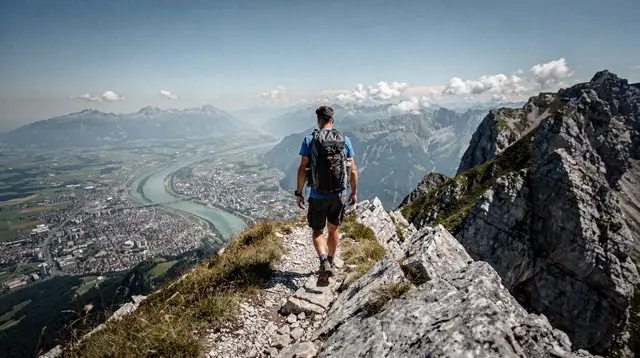
High trails above roughly 2,000 metres are usually clear from late June or July, depending on how much snow fell the previous winter, and stay open into September or early October. Mid-April to the end of May and all of November are a shoulder season when many lifts and huts close for maintenance, so hiking is limited to lower, snow-free ground.
Why the calendar on a travel blog is often wrong for these mountains
Search for hiking season dates around Innsbruck and it is easy to come away with the impression that the trails open the moment the snow melts in the valley and stay open until the first autumn frost. They don’t. The Inn valley floor sits at about 574 metres, but the trails worth hiking here run from roughly 1,800 metres up past 2,300 metres, and the gap between valley conditions and ridge conditions is the single most important thing to understand before planning a hiking trip to Tyrol. A green, 22°C afternoon in the old town tells you almost nothing about what the path looks like above the treeline.
This page is a season-by-season reference, not a route guide. For actual trails, distances and difficulty ratings, the dedicated pages for the Nordkette, the Patscherkofel, the Karwendel and the Stubai Glacier go into detail. What follows is the timing question: when do those trails actually become walkable, why does that date move around, and what should you plan for if you are travelling outside the reliable window.
The honest headline: late June or July, not May
The single most useful fact on this page is also the one most often glossed over elsewhere: high trails above about 2,000 metres around Innsbruck are typically clear of snow and safely walkable from late June or July, not from the moment spring arrives in the valley. Some years it happens earlier, some years later, and the difference comes down to one variable — how much snow fell the previous winter, and how warm the following spring was.
A winter with heavy, late snowfall can push the safe opening of high routes into mid-July. A light winter followed by a warm April and May can open the same trails by mid-June. There is no fixed date that applies every year, which is why any page promising an exact calendar day for trail opening is guessing. The reliable approach is to check the current status of a specific lift, hut or trail section close to your travel dates rather than to plan around a remembered date from a previous year or trip.
South-facing, lower-elevation ground clears earlier than this general window. Parts of the Patscherkofel and the lower reaches of the Nordkette around Hungerburg and Arzler Alm are often walkable from May. It is the higher, more exposed and often north-facing terrain — toward Hafelekar and across the Karwendel ridgelines — that needs the extra month.
The shoulder season: mid-April to the end of May, and November
Between roughly mid-April and the end of May, and again through November, Innsbruck sits in what is honestly its quietest and cheapest stretch of the year — and its weakest for mountain hiking. This is when many cable cars and staffed mountain huts close entirely for their annual maintenance, a routine that has nothing to do with weather and everything to do with servicing lift machinery and reopening huts that closed for winter. A cable car can be running fine in March for skiers and then close for three or four weeks in April regardless of how clear the trails look.
At the same time, snow genuinely does linger on shaded and north-facing slopes above roughly 1,800-2,000 metres well into May, and often starts returning to the same ground in October or November. So the shoulder season is a double closure: lifts and huts shut for servicing on a schedule, and the terrain itself is often still unsafe or simply covered on the higher routes even where a lift happens to be running.
None of this makes the shoulder season a bad time to visit Innsbruck — it is arguably the best value stretch of the year for the city itself, and lower valley walks, the old town and museums are all fully open. It is specifically a bad assumption to arrive expecting a full high-mountain hiking programme. The shoulder season page covers what does and doesn’t work at that time of year in more detail.
| Period | High trails (2,000 m+) | Lower trails, valley walks | Lifts and huts |
|---|---|---|---|
| Mid-April to end of May | Usually still snow-affected | Mostly walkable from May | Many closed for annual maintenance |
| Late June to September | Typically clear, weather-dependent | Fully open | Fully open |
| October | Narrowing window, early snow possible | Generally open | Some seasonal closures begin |
| November | Closed or unsafe | Open but cold and short days | Widespread maintenance closures |
| December to March | Ski season, not hiking | Limited, snow underfoot | Open for winter sports |
Reading the altitude gap: 574 m to 2,256 m in one afternoon
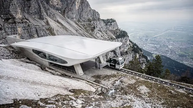
Temperature drops by roughly 0.6°C for every 100 metres of altitude gained, and Innsbruck’s cable cars make that arithmetic feel dramatic rather than theoretical. The city centre sits at about 574 metres. The Seegrube station on the Nordkette, reached in stages by the Hungerburgbahn and Seegrubenbahn, sits at roughly 1,905 metres. Hafelekar, the top station, is at about 2,256 metres, close to the Hafelekarspitze summit at 2,334 metres. The whole ascent from the valley floor takes around 20-25 minutes.
That means a genuinely common scenario: 25°C and sunny on Maria-Theresien-Straße, and close to freezing with old snow patches lying around the Seegrube station on the very same June or even July afternoon. It is not a rare edge case, it is the normal relationship between the valley and the ridge for most of the hiking season, and it is the reason layered clothing matters here in a way it might not on a lowland hiking trip.
The practical planning consequence is that “it’s hiking season” in the valley does not automatically mean every route above it is comfortable or even open. Wind exposure adds to the effect: an unshaded ridge at 2,000 metres in a stiff breeze feels colder than the thermometer reading alone suggests, which is one more reason a specific route’s current conditions matter more than the calendar month.
Mountain by mountain, in brief
Each of the main hiking areas around Innsbruck has its own opening pattern, driven by aspect, altitude and the lift infrastructure that serves it. The short version, with links to the full route guides:
- Nordkette: the closest and highest-profile option, reached directly from the city by the Hungerburgbahn, Seegrubenbahn and Hafelekarbahn. Lower trails near Hungerburg and Arzler Alm open earliest; the exposed ridge routes toward Hafelekar need the full late-June-to-July window. Full detail on the Nordkette hiking trails guide.
- Patscherkofel: the gentler mountain south of the city above Igls, generally opening a little earlier than the Nordkette thanks to more south-facing terrain. See the Patscherkofel hiking guide.
- Karwendel: the range north of the city and around Leutasch and Zirl, with longer, higher routes that tend to open on the later side of the general window. Covered in the Karwendel hiking guide.
- Stubai Glacier: a different case entirely, since it is glacier terrain rather than a summer hiking trail network, with its own long operating season centred on the TOP OF TYROL platform. See the Stubai Glacier hiking and viewing platform guide.
- Seefeld plateau: sitting at a more moderate 1,180 metres, Seefeld’s rolling terrain is walkable earlier and later in the year than the higher ranges, and suits families and less committed hikers well. Detail in the Seefeld plateau hiking guide.
Choosing between a guided sunrise hike and going it alone
Timing uncertainty is exactly the kind of problem a local guide solves without you having to track lift schedules and snow reports yourself. A guided outing like the sunrise hike up to Rangger Köpfl runs on a route and schedule the operator has already checked against current conditions, which removes the single biggest planning risk covered on this page.
For a gentler introduction to high-altitude walking that suits families or first-time visitors to the Alps, the relaxed guided walk across the Seefeld plateau stays on more forgiving terrain that tends to be accessible earlier in the season than the higher summit routes. Travellers after a proper summit day, on the other hand, can look at the guided summit hike to the Rosskogel at 2,646 metres, which is squarely in the category of high route that depends on the late-June-or-later window discussed above.
Closer to the city and manageable as a half-day outing, the sunrise tour on the Patscherkofel is a good option for visitors who want a mountain-morning experience without committing to a full high-altitude day hike.
Best mountain huts and where to sleep along a high route
Mountain huts are woven into the shoulder-season closure pattern described above: they close for the same maintenance window as the cable cars serving them, and reopening dates vary hut by hut rather than following one fixed regional calendar. Anyone planning a multi-day route or simply a lunch stop at altitude should check a specific hut’s dates rather than assume all huts follow the same schedule. The best mountain huts around Innsbruck guide lists options and their general season, and pairs well with the multi-day itinerary on the alpine hiking week itinerary.
Planning around the uncertainty, not against it
The most useful mindset for a hiking trip to Tyrol is to treat the season window as a range to check close to your travel date, not a fixed block to book against months in advance. A trip booked for the third week of June could land in a fully open, glorious hiking window, or in a year where the high trails are still a few weeks from clearing — both are normal outcomes of the same average pattern. Building in flexibility, favouring lower and south-facing routes early in the window, and checking the current best time to visit Innsbruck guidance closer to departure all reduce the risk of arriving to find a route still closed.
It is also worth reading the shoulder season honestly rather than as a problem to route around at all costs. The why the shoulder seasons are worth the risk piece makes the case that quieter crowds, lower prices and a still-beautiful old town can outweigh a limited hiking programme for travellers whose trip is not built entirely around summit routes. And for a sense of just how fast the terrain changes once the cable cars are running, the from city centre to 2,000 metres in 30 minutes piece walks through that ascent in more detail.
FAQ: hiking season timing around Innsbruck
Is Innsbruck a good hiking destination all year round?
No. Innsbruck is an excellent base for hiking from roughly late June to September, and for lower-altitude walks a bit earlier and later, but it is not a year-round hiking destination. Outside that window, winter sports or lower-elevation walking are the honest options.
Why can’t I hike the high trails in April or May?
Snow lingers on north-facing slopes and shaded gullies well into May at altitudes above about 1,800-2,000 metres, and many cable cars and mountain huts close for their annual maintenance between mid-April and the end of May. Trails can look walkable from the valley and still hide snow bridges or ice higher up.
Does the opening date change every year?
Yes, and by more than people expect. It depends on how much snow fell the previous winter and how warm the spring was, so late June in a light-snow year can mean late July after a heavy one. Checking a specific lift or hut’s current status before travelling is more reliable than any fixed calendar date.
Why is it so much colder on the Seegrube than in the old town?
The city centre sits at about 574 metres while the Seegrube station on the Nordkette is at roughly 1,905 metres, a difference of over 1,300 metres reached in about 20 minutes by cable car. Temperature drops by roughly 0.6°C per 100 metres of altitude, so a 25°C afternoon in the old town can still mean single digits and a cold wind at the top.
Is November a good time to visit Innsbruck for hiking?
November is one of the quietest and cheapest months, but it is a poor month for mountain hiking. Many cable cars and huts are closed for maintenance, early snow can already be sitting on north-facing terrain, and days are short. It suits city sightseeing and lower valley walks rather than a mountain hiking trip.
Which mountains around Innsbruck are hikeable earliest in the season?
Lower, south-facing ground clears first: parts of the Patscherkofel and the lower Nordkette trails around Hungerburg and Arzler Alm are often walkable from May, while the exposed, higher terrain toward Hafelekar and the Karwendel ridgelines typically needs until late June or July.
Do I need to book lift tickets or check hut opening dates in advance?
It is worth checking rather than assuming. Cable cars and staffed mountain huts publish their own seasonal operating dates, and these shift year to year with snow conditions, so a specific lift or hut can still be closed even once the general hiking season has started elsewhere in the valley.
Mountain hiking on GetYourGuide
Verified deep-linked GetYourGuide tours. Book through these links and we earn a small commission at no cost to you.
GetYourGuide does not provide a product photo for this activity — the image shows the meeting point, photographed by us.