Hiking the Stubai Glacier and the TOP OF TYROL Platform
Can you hike around the Stubai Glacier, and what is the TOP OF TYROL platform?
Yes, but as high-altitude walking around the ski lifts and glacier edge rather than a self-guided glacier crossing. TOP OF TYROL is the viewing platform at about 3,210 m, reached by cable car, with marked paths nearby. The Stubai Glacier has a long season from roughly autumn to early summer, but unlike Hintertux in the Zillertal it does not operate every day of the year.
What hiking at the Stubai Glacier actually means
The Stubai Glacier is Austria’s largest glacier ski area, and it sits at the very head of the Stubai valley, well beyond the villages of Neustift im Stubaital and Fulpmes. That single fact shapes everything about hiking here: this is not a green-meadow trailhead, it is a working glacier ski resort above the tree line, with lift stations, cables and machinery visible in every direction.
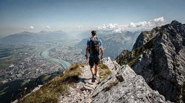
If your picture of “glacier hiking” is a quiet ridge walk with nobody else around, the Stubai valley lower down or the trails around Nordkette and Patscherkofel closer to the city are a better fit. What the glacier offers instead is something else entirely: a short cable car ride from a valley floor at working altitude straight up into genuine high-alpine terrain, with snow patches, glacier views and a viewing platform that most visitors to Tyrol never get near.
The honest starting point is that you do not “hike the glacier” the way you hike a summer meadow trail. The ice itself is crevassed terrain, and walking on it without a guide and the right equipment is not something this page recommends or that most visitors attempt. What is genuinely open to walkers is the network of marked paths around the upper lift stations, the viewpoints along the ridge, and the approach to and around the TOP OF TYROL platform itself. Treat a visit here as high-altitude sightseeing with some short, rewarding walks attached, not as an alpine trekking day.
The TOP OF TYROL platform
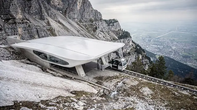
TOP OF TYROL is the name given to the viewing platform at the upper station of the Stubai Glacier lift system, at roughly 3,210 m. It is built out from the mountainside so that the view is not interrupted by the building behind you: on a clear day you look across a wide arc of glaciated peaks, with the Stubai valley dropping away below and, further off, ranges that stretch toward the Ötztal and beyond. This is one of the more dramatic high-altitude viewpoints reachable by lift in this part of the Alps, and unlike a mountain summit it requires no fitness beyond being able to walk from the cable car doors to the platform itself.
Because the platform sits above 3,000 m, the practical rules of altitude apply even on an otherwise easy day. Weather changes fast up here — cloud can roll in within minutes, temperatures sit well below what they are in the valley, and wind at the platform can make it feel far colder than the thermometer suggests. Sun exposure is also stronger at this height, particularly with snow underfoot reflecting glare, so sunglasses and sun cream matter here more than they might feel necessary for lower down. None of this makes the platform inaccessible; it simply means it should be treated with the same respect as any high-altitude viewpoint, dressed for accordingly.
What the walking is actually like
Around the top station and the TOP OF TYROL platform, a handful of short marked paths let you move between viewpoints without needing technical mountain experience. These are the realistic scope of “hiking” directly at the glacier: brief, well-marked stretches on maintained ground, rather than multi-hour routes across the ice or moraine.
If you are looking for a longer day’s walking with a real sense of remoteness, that is better found on the trails lower in the Stubai valley, or on routes covered in the wider hiking trails around Nordkette and the guide to Patscherkofel’s hiking network, both of which sit closer to Innsbruck and offer more varied terrain without the glacier’s altitude constraints.
For visitors who want a proper walking day that starts from the glacier’s lift system and still finishes at a hut with food and a view, one option worth knowing about is a guided route to an Alpine hut in the Stubai Alps, built around the kind of hearty mountain cooking Tyrolean huts are known for:
a guided hike to an Alpine hut in the Stubai Alps with a proper mountain lunch includedThat kind of route bridges the gap between the short platform walks at the very top and a full day’s trekking, and it is the more satisfying choice for anyone who wants to actually earn the view rather than ride straight up to it.
Not open every day of the year — the Hintertux comparison
This is the single most important correction to make before planning around the Stubai Glacier: it is not open every day of the year. It runs a long season by Alpine standards, broadly stretching from autumn through the winter and into early summer, which is why it is popular with both skiers extending their season and hikers visiting in the shoulder months. But it does close for periods, typically a stretch in the height of summer and again around seasonal transitions, and those closure dates shift from year to year depending on conditions.
The glacier that genuinely operates every day of the year in Tyrol is Hintertux, over in the Zillertal, not the Stubai Glacier. The two are easy to mix up because both are described as “year-round glacier skiing” destinations in general terms, but only one of them actually delivers on that promise without exception.
The distinction is covered in more detail in Stubai Glacier versus Hintertux, and it is worth reading before you build a trip around the assumption that the lifts will be running on any given date. The practical takeaway is simple: whatever month you are planning for, check the current operating calendar directly before travelling out to the glacier, rather than assuming a “year-round” reputation guarantees an open lift on your specific day.
Stubai Glacier or Ötztal for a glacier day
Innsbruck sits within reach of more than one glaciated area, and the Stubai Glacier is not the only option for a high-altitude day out. The Ötztal, further west, has its own glacier terrain and its own high-altitude attractions. Choosing between them usually comes down to logistics — how the rest of your day or trip is structured — rather than one destination being clearly better than the other, and the comparison is laid out properly in Stubai or Ötztal for glacier skiing.
For a hiking and viewing day specifically, the Stubai Glacier’s advantage is proximity: it is the closer of the two to Innsbruck, which matters if you are not renting a car and are relying on public transport out to Stubai, Ötztal and Seefeld.
Getting there and what to plan around
The Stubai Glacier sits at the far end of the Stubai valley, well beyond Neustift im Stubaital, and the final approach road climbs steadily to the lift base station. Regional buses run from Innsbruck into the valley, and the route is covered alongside the other main valley connections in the guide to getting to Stubai, Ötztal and Seefeld by public transport. Driving is straightforward but worth planning with the same general rules that apply across Tyrol — a motorway vignette and, in winter conditions, appropriate tyres — details of which sit in the broader driving in Tyrol guide.
Because the round trip from Innsbruck, up the valley and up the lift system, and back down again takes a meaningful chunk of a day, it is worth deciding in advance how much time you actually want at altitude versus how much you want to see lower in the valley on the way. A two-day structure that pairs a glacier day with time in the villages and lower trails is laid out in the Stubai valley two-day itinerary, and for a longer stay built specifically around walking, the alpine hiking week itinerary threads the Stubai Glacier in alongside routes on Nordkette and Patscherkofel rather than treating it as a stand-alone destination.
Packing and altitude basics
A visit here rewards the same preparation as any high-altitude Alpine outing, adjusted for the fact that most of the “hiking” is short and platform-based rather than a long trek. A warm layer, wind protection, sturdy footwear even for short walks on snow or wet rock, sunglasses and sun cream are the essentials, and none of them are optional simply because the walking itself is brief — the exposure at 3,000 m-plus is real regardless of how far you actually walk.
A general packing rundown for the destination as a whole, including what changes by season, is in what to pack for Innsbruck, and anyone timing a visit around the wider question of when Tyrol’s high trails are actually walkable should read when to hike in Tyrol, a season guide before committing to dates.
For those who want more structured guidance at altitude rather than exploring the marked paths independently, a short introduction to moving safely at the glacier’s edge is available as a guided experience with basic training included:
a guided glacier experience at the Stubai Glacier with basic safety trainingThat kind of structured introduction is the sensible middle ground for anyone curious about the glacier environment beyond the viewing platform, without stepping into independent glacier trekking.
What a visit here actually looks like
Strip away the logistics and a typical visit follows a simple shape. You arrive at the lift base station having driven or bussed up the valley, ride one or more cable car stages up through the ski infrastructure, and step out at the top into thin, cold air and a view that has nothing to do with the working machinery below it.
Most visitors spend their time at altitude moving between the TOP OF TYROL platform and the handful of marked paths nearby, stopping often for photographs because the light and the scale of the peaks around you genuinely do change by the minute up here. There is usually the option of something to eat at the top station before heading back down, which matters more than it sounds once the cold has been working on you for an hour or two.
None of that requires fitness beyond walking comfortably from a cable car door to a viewpoint and back, which is exactly why the glacier suits such a wide range of visitors: families with older children, grandparents who cannot manage a mountain trail, and hikers using it as a gentler bookend to a more demanding day elsewhere in Tyrol. What it does not suit is anyone expecting a wilderness experience — the lift stations, cables and other visitors are a constant presence, and treating the visit as sightseeing with a short walk attached, rather than as a hike in its own right, is the frame that leaves people satisfied rather than disappointed.
What this page won’t guess at
Lift ticket prices, exact opening and closing dates for the season, and the precise timetable for the buses up the valley all change from one year to the next, and printing a specific figure here that goes stale within a season does more harm than good. The honest approach is to treat this page as a guide to what the experience is like and how to think about planning it, and to confirm the numbers that actually matter — the current price, whether the lifts are running on your date, and the bus times you need — directly with the operator or the regional transport provider shortly before you travel.
The same caution applies to restaurant and hut names at the top station: what is open and what it serves can change between seasons, so it is worth checking on arrival rather than building a plan around a specific menu or an opening time fixed months in advance.
This is not a page hedging out of laziness. Because the glacier does not run every day of the year and because Alpine lift pricing is revised regularly, a guide that quoted todays numbers would be actively misleading readers within a matter of months. Treat the operating-season point made earlier in this page as the one fact worth carrying forward without a specific date attached to it, and treat everything else time-sensitive as a five-minute check before you leave Innsbruck.
Beyond the glacier itself
Not every visitor wants to spend a full day at altitude, and the lower Stubai valley and the hills around Innsbruck offer gentler alternatives with similar panoramic rewards. A shorter, easier option closer to the city is a panoramic walk across open meadows with wide valley views, without the altitude or the lift queues:
a panoramic hike across the Telfer Wiesen above InnsbruckAnd for hikers willing to look slightly further afield, the lake and ridge walking on the Seefeld plateau offers a genuinely different kind of high-altitude scenery — gentler underfoot, greener, and centred on water rather than ice:
a two-lake hike to the Brunschkopf near SeefeldBoth are useful if the glacier’s weather forecast turns against you, or if one member of a group wants a full-day trek while another prefers something shorter and lower.
Making it part of a bigger Tyrol picture
The Stubai Glacier earns its place on an Innsbruck itinerary as a striking half-day or full-day excursion rather than as the centrepiece of a hiking trip. It pairs naturally with time spent in things to do around the Stubai valley, and with a broader understanding of how many days a Tyrol trip actually needs, covered in how many days in Innsbruck. Whatever the season, the two facts worth carrying into any planning are the same ones this page opened with: the platform and paths at the top are genuinely spectacular and easy to reach, and the glacier is not open every day of the year the way Hintertux is — so check current dates before you build a day around it.
Mountain hiking on GetYourGuide
Verified deep-linked GetYourGuide tours. Book through these links and we earn a small commission at no cost to you.
GetYourGuide does not provide a product photo for this activity — the image shows the meeting point, photographed by us.