Nordkette Hiking Trails: Routes Above Innsbruck
What hiking trails start on the Nordkette above Innsbruck?
The Nordkette is reached from central Innsbruck in about 20-25 minutes on three linked lifts, ending at Hafelekar (2,256 m) below the Hafelekarspitze summit (2,334 m). From the mid-station at Seegrube (1,905 m) and from Hafelekar itself, marked ridge and balcony trails lead toward the Arzler Alm, along the Goetheweg, and into the wider Karwendel range, with route choice, timing and difficulty best confirmed on-site or with the lift operator.
Getting from the city to the trailhead
No other Alpine city puts high mountain hiking this close to its front door. From the centre of Innsbruck, three separate lifts carry walkers from the valley floor at about 574 m to Hafelekar at 2,256 m in roughly 20 to 25 minutes: the Hungerburgbahn funicular up to Hungerburg at about 860 m, the Seegrubenbahn on to Seegrube at about 1,905 m, and the Hafelekarbahn for the final stretch to Hafelekar at about 2,256 m, just below the Hafelekarspitze summit at 2,334 m.
Treating this as a single cable car is a common mistake — it is three distinct systems, each with its own station, and each worth understanding before you plan a hike around them. For the full mechanics of tickets, timetables and connections between the three stages, the dedicated Nordkette cable car guide covers that ground in detail; this page is about what opens up once you step off at the top.
Because the ride is so quick, the Nordkette works equally well as a half-day outing squeezed between other plans or as the anchor of a full day in the mountains. It also means the walk down through the different vegetation zones — dwarf pine and alpine meadow near Hafelekar, spruce forest lower down — can be as interesting as the ridge walking up top.
What kind of hiking is up there
The Nordkette is not a single trail but a fan of options that spread out from two very different stations, and picking the right one matters more than picking a season.
From Seegrube (about 1,905 m). This mid-station has the gentler terrain: wide gravel paths, a sun terrace, and walks that suit families and casual visitors who want mountain views without technical ground underfoot. Short loops around the station give a taste of the panorama over Innsbruck and the Inn valley without committing to serious altitude gain. It is also the turning point for people who ride up mainly for the view and a meal, which the Hafelekar-Seegrube hiking and views guide covers in more depth.
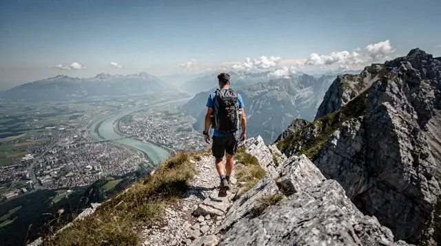
From Hafelekar (about 2,256 m). This is where the terrain changes character. Paths from the upper station run along exposed ridgeline and scree slopes toward the Hafelekarspitze summit at 2,334 m, and onward into the Karwendel. This is proper mountain walking — sturdy boots, layered clothing and a head for exposed ground are the baseline, not an option. Weather at this altitude can shift quickly even when the city below is warm and clear, and posted trail information at the station is the right source for current conditions, not a fixed expectation carried up from home.
Into the wider Karwendel. Trails from the ridge above Hafelekar connect into the Karwendel Alpine Park, one of the largest protected nature areas in the Alps. A short there-and-back near the lift station can, for hikers equipped and prepared for it, extend into a much longer traverse. The Karwendel hiking guide is the place to look for that bigger picture; this page stays focused on what is reachable directly from the Nordkette lifts.
A useful way to think about the choice: Seegrube rewards people who want an easy mountain afternoon, Hafelekar rewards people who came to hike. Trying to do a serious Hafelekar route on a Seegrube-level plan, or the reverse, is the most common mismatch visitors make.
A quick comparison of the two starting points
| Starting station | Approx. altitude | Terrain | Best suited to |
|---|---|---|---|
| Seegrube | ~1,905 m | Wide paths, gentle gradients, terrace | Families, casual walkers, short outings |
| Hafelekar | ~2,256 m | Exposed ridge, scree, alpine terrain | Experienced hikers, longer routes, Karwendel connections |
Exact walking times and distances vary by route and are not fixed here on purpose — trail conditions, snow cover and personal pace all change them. The signage at each station, and the lift operator’s own trail information, is the reliable source once you are actually there.
Why this connection is unusual
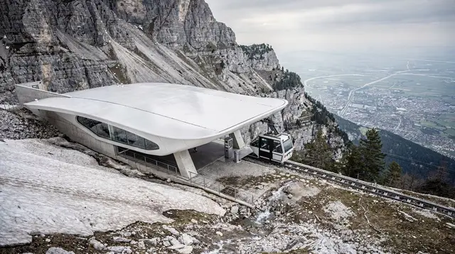
Few cities anywhere let you walk out of a station at 2,256 m having started the day at breakfast in a city of about 131,000 people. The three-stage lift system — Hungerburgbahn, Seegrubenbahn, Hafelekarbahn — was built precisely to make that possible, and the Hungerburgbahn’s stations, designed by Zaha Hadid and opened in 2007, are themselves part of the reason the ride up feels like an event rather than a formality. That design story, and the practical questions around riding all three stages, belong to the Hungerburgbahn funicular guide rather than to this page.
The result is that a hiking day on the Nordkette does not need a car, a shuttle booking or an early start from a mountain village — it starts from wherever you are staying in Innsbruck, on public transport or on foot to the valley station.
Guided options if you would rather not plan the route yourself
Independent hiking on the Nordkette is straightforward for the Seegrube side and demanding on the Hafelekar side, so a guided option is worth considering if you want local knowledge of current conditions or simply prefer not to navigate alone. A panoramic hike across the Telfer Wiesen meadows above the city covers some of the gentler balcony terrain with a guide setting the pace.
For something more tailored, a private guided mountain hike can be shaped around your fitness level and the time you have, which is useful if your group splits between Seegrube-level walkers and people wanting the Hafelekar ridge.
Hikers with a specific technical interest sometimes combine the Nordkette with amateur radio activity — a summit hike with radio equipment for Summits on the Air is a niche but genuine option for that audience. And for a different way to cover ground above the city without walking every metre of it, a guided e-bike tour along lower Nordkette trails suits visitors who want the mountain scenery with less time on foot.
Practical notes before you go
Altitude and weather. The jump from valley floor to Hafelekar is over 1,600 vertical metres, and conditions at the top can differ sharply from the city — expect it to be markedly cooler, and check for wind and cloud before committing to exposed ridgeline. Snow patches can persist into early summer at this altitude and return early in autumn.
Footwear and gear. Sturdy, ankle-supporting boots are the minimum for anything beyond the short paths near Seegrube. Layers matter more than a single warm jacket, since temperature and wind exposure change quickly between the forested lower stations and the open ridge above Hafelekar.
Timing the lifts, not just the trail. Because the hike depends on three separate connections, build in time for each transfer rather than assuming a seamless ride, especially in high season when queues form at Hungerburg. The Nordkette cable car guide has the detail on tickets and connection timing.
Mountain huts. Refreshment points near the upper stations and along nearby ridges are a genuine feature of hiking here, and the best mountain huts around Innsbruck guide rounds up options worth planning a stop around.
Combining with other Innsbruck mountains. Visitors staying several days sometimes compare the Nordkette with the gentler Patscherkofel on the opposite side of the valley; the Nordkette or Patscherkofel guide sets out how the two differ for hikers specifically.
What a morning or afternoon up there actually involves
A typical outing on the Nordkette follows a simple shape, even if the details change with the station you choose. You start in central Innsbruck, board the Hungerburgbahn, and by the time you step out at Hungerburg the city already looks small below the funicular’s glass and concrete curves. From there it is a short walk to the Seegrubenbahn station, and a second, steeper ride before the tree line falls away and the valley opens out beneath the cabin.
At Seegrube, most visitors pause. The terrace, the view down the Inn valley, and the choice of gentle paths around the station make it a natural place to decide how the rest of the day will go — a short loop and something to eat, or the third lift up to Hafelekar for something more demanding. Walkers heading further up should expect the character of the ground to change almost as soon as they step off at Hafelekar: gravel and grass give way to scree and exposed rock within a few hundred metres, and the wind is usually noticeably stronger than at Seegrube even on a calm day in the city below.
Coming back down is its own part of the day, not an afterthought. Some hikers ride all three lifts back to the valley; others walk some or all of the descent, dropping through alpine meadow into spruce forest as the altitude falls, which changes the feel of the walk more than any single viewpoint does. Either way, building slack into the return leg — rather than timing it to the last lift of the day — avoids the kind of rush that turns a good afternoon into a stressful one.
When to go, and when to think twice
Summer is the straightforward season here: the three lifts run their fullest timetable, the paths above both Seegrube and Hafelekar are normally clear of snow, and the huts and terraces are open. Outside that window, the picture is less simple.
In the shoulder periods — roughly mid-April to the end of May, and again through November — reduced snow cover on the valley floor does not mean the mountain is fully open: some lifts, huts and paths close for maintenance or because conditions higher up are still wintry, and what is open can change from one week to the next. Anyone planning a Nordkette day in those months should check current status with the lift operator rather than assuming a mild forecast in the city means the same thing at 2,256 m.
Winter turns most of the Nordkette’s upper terrain into a ski and snow-sports area rather than a hiking one, though some lower paths near Hungerburg and Seegrube can still be walked with the right footwear and caution.
One more local quirk worth knowing about before you go: Innsbruck sits in a valley prone to föhn, a warm, dry wind that can clear the sky to a hard blue within a matter of hours, and that some people find brings on headaches or a general low mood. A föhn day can mean exceptional visibility from Hafelekar over the Inn valley and the peaks beyond it, and it can also mean stronger gusts on the exposed ridge than the calm conditions in the city centre would suggest. Neither is a reason to cancel a hike on its own, but both are reasons to judge conditions at the top rather than from the valley floor.
What this page cannot tell you
Trail names, exact distances and walking times for individual routes above Seegrube and Hafelekar are deliberately left out of this guide. Snow cover, path maintenance and even which sections are officially open change often enough at this altitude that a fixed list would go stale within a season, sometimes within weeks. The reliable sources are the ones that update in real time: the posted signage at each station, and the current trail and lift information from the operator running the Nordkette lifts. Treat anything you read here as a starting point for planning, not a substitute for checking on the day.
The same caution applies to what a guide or an outfitter can promise in advance. Weather at 2,256 m can shift faster than a forecast made at valley level accounts for, and a route that looks straightforward on a map can be a poor idea in low cloud or high wind. Building in the flexibility to change plans once you see conditions at Hungerburg or Seegrube — rather than committing to a summit push from the city — is a better strategy than working from what this page, or any page, said in advance.
Nordkette hiking: your questions answered
Is the Nordkette one cable car or several?
It is three separate lifts used in sequence: the Hungerburgbahn funicular from the city to Hungerburg, the Seegrubenbahn from Hungerburg to Seegrube, and the Hafelekarbahn from Seegrube to Hafelekar. Each has its own station, ticket and operating schedule.
How long does it take to get from Innsbruck to Hafelekar?
Around 20-25 minutes covers all three legs when connections are smooth, which makes it one of the fastest routes from a European city centre to high mountain terrain. Add time for waiting at each station during busy periods.
Can beginners hike on the Nordkette?
Seegrube (1,905 m) has gentler paths and a restaurant terrace that suit less experienced walkers, while the terrain above Hafelekar (2,256 m) toward the Hafelekarspitze is steeper, exposed rock and scree. Choose your starting station based on the terrain you actually want.
Do I need to book the Nordkette lifts in advance?
The lifts run on a published timetable and tickets are normally bought at the stations or online through the operator, not through a hiking tour booking. A guided hike booked separately can include transport, but check what each listing covers before assuming lift fare is included.
What should I check before hiking above Hafelekar?
Snow can linger at 2,000 m or more well into early summer and return early in autumn, so check the operator’s current trail and lift status and the posted signage at Hafelekar before setting off, rather than relying on a season alone.
Is the Nordkette connected to the wider Karwendel hiking network?
Yes. Trails from Hafelekar and the ridge above Seegrube connect into the Karwendel Alpine Park, one of the largest protected areas in the Alps, so a short outing above Innsbruck can extend into a much longer route for those equipped for it.
Is the Nordkette good for a sunrise or sunset hike?
It is a popular choice because the lift ride is short and the panorama over Innsbruck and the Inn valley is immediate, but early and late services are limited to certain seasons and days, so confirm the current timetable before planning around a specific sunrise or sunset.
Mountain hiking on GetYourGuide
Verified deep-linked GetYourGuide tours. Book through these links and we earn a small commission at no cost to you.
GetYourGuide does not provide a product photo for this activity — the image shows the meeting point, photographed by us.