Seegrube and Hafelekar: What to Do at the Top of the Nordkette
What is there to actually do at Seegrube and Hafelekar?
Seegrube (about 1,905 m) has a sun terrace, a restaurant and short panoramic paths good for anyone; Hafelekar (about 2,256 m) is a short, steep walk further up to rockier, more exposed viewpoints below the Hafelekarspitze summit at 2,334 m. Both look straight down onto Innsbruck at 574 m, and both can be windy and cold even when the city is warm.
The cabins get you up the Nordkette in around 20 to 25 minutes; what you do once you step out at the top is a different question, and it splits into two very different stops. This guide covers only that: what Seegrube and Hafelekar actually offer once you are standing on them, not the ride itself and not the long-distance routes that continue north into the Karwendel. For the funicular and cable car stages, see the Nordkette cable car guide and the separate page on the Zaha Hadid-designed Hungerburgbahn stations.
Two Stops, Two Very Different Mountains
Seegrube, at roughly 1,905 m, and Hafelekar, at roughly 2,256 m, sit on the same Nordkette ridge but feel like different places. Seegrube is broad, sunny and developed: a large terrace, a restaurant, gentle paths and views that need no effort to reach. Hafelekar is smaller, rockier and more exposed, reached either by cable car directly or by a short, steep walk up from Seegrube. Above Hafelekar station, the actual summit of the Hafelekarspitze rises to 2,334 m, a further scramble rather than a stroll.
Both stops look straight down onto Innsbruck at 574 m, and it is that vertical drop, nearly 1,700 metres from the city centre to Hafelekar, that makes the Nordkette unusual among Alpine viewpoints reachable from a city. Few European capitals or regional capitals put high mountain terrain this close to their historic core, and the Nordkette is regularly described as the fastest such ascent in Europe.
What There Is to Do at Seegrube
Most visitors’ Nordkette day is really a Seegrube day, and that is a reasonable choice. The station sits on a wide shoulder of the mountain with unobstructed views south across the Inn valley to the Patscherkofel and the softer mountains around Igls. On a clear day the sightline runs well beyond the city, over the Wipptal and toward the Brenner pass.
The terrace and restaurant. Seegrube’s restaurant serves hot food, drinks and cake, with outdoor seating that catches the sun for most of the day. It is the only proper meal stop on this part of the mountain — Hafelekar has none — so many people eat here either before or after walking higher.
Short panoramic paths. A network of easy gravel and paved paths circles the immediate area around the station, needing no hiking experience or special footwear beyond sensible shoes. These are the paths worth taking with young children, grandparents, or anyone happy to trade a summit for an easy, high-altitude view.
Longer trails from Seegrube. For those who want more, marked trails head off toward the Rumer Alm and the wider Nordkette hiking network; the full route options are covered on the dedicated Nordkette hiking trails guide and the roundup of mountain huts around Innsbruck. In winter this same terrain becomes freeride and off-piste skiing terrain, described separately on the Nordkette skiing and freeride guide.
Photography. The terrace itself is one of the more reliable sunrise and sunset spots above the city, since the first lift up runs early enough on selected mornings to catch the light. Details on timing and access sit in the Nordkette sunrise photography guide.
What There Is to Do at Hafelekar
Hafelekar is smaller and starker. There is a viewing platform immediately by the station, a small shelter, and rock and scree underfoot rather than gravel paths. What draws people up here is the drop: the view down to Innsbruck feels closer and steeper than from Seegrube, and to the north the jagged wall of the Karwendel range fills the horizon instead of city streets.
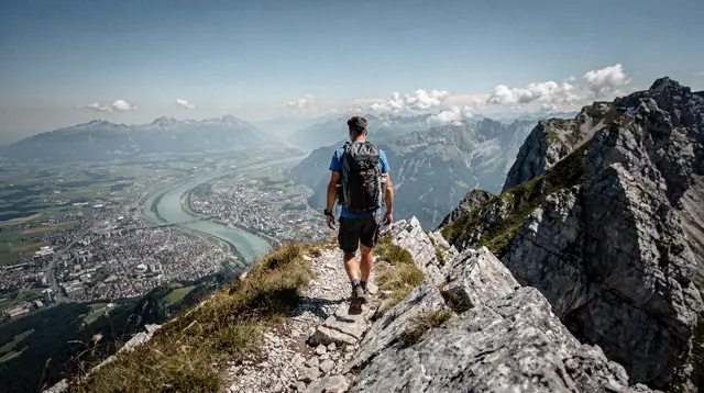
The summit walk to Hafelekarspitze. From the station, a marked path climbs a further stretch to the actual summit cross at 2,334 m. It is short in distance but genuinely alpine in character: loose rock, some exposure, and no barriers on the narrower sections. In good weather with proper footwear it is well within reach of a reasonably fit visitor; in wind, rain or when the rock is wet, it is better left for another day. This is also the point beyond which longer Karwendel ridge routes begin, which this guide does not cover — they are a separate undertaking requiring mountain experience and planning of their own.
The walk down to Seegrube (or up from it). Many visitors treat Hafelekar and Seegrube as one outing, walking the connecting path between the two rather than riding the cable car both ways. It takes roughly 20 to 30 minutes, loses or gains about 350 metres of height, and is steep and unpaved throughout. It rewards good shoes and a bit of care rather than fitness alone.
What is not here. There is no restaurant at Hafelekar, no shop, and in poor weather very little shelter. Anyone planning to spend real time at altitude should build the visit around Seegrube’s terrace and treat Hafelekar as the short, higher add-on rather than the main event.
The Temperature Drop Is the Real Story
The single most common surprise on this mountain is not the view, it is the air. Innsbruck’s centre sits at 574 m; Hafelekar sits at 2,256 m. That difference alone typically costs somewhere in the region of 10 degrees Celsius, before accounting for wind, which on an exposed ridge like this can make the effective temperature drop feel considerably sharper. It is entirely normal to leave the old town in a T-shirt on a 25-degree June afternoon and find old snow patches, a biting wind and jackets zipped to the chin at Seegrube an hour later.
| Location | Altitude | Typical feel relative to city centre |
|---|---|---|
| Innsbruck city centre | 574 m | baseline |
| Hungerburg | ~860 m | slightly cooler |
| Seegrube | ~1,905 m | noticeably cooler, windier |
| Hafelekar | ~2,256 m | cold, often windy, snow patches possible into early summer |
| Hafelekarspitze summit | 2,334 m | most exposed point on the route |
The practical takeaway is simple: dress for the top, not for the city, whatever the forecast says at street level. A windproof layer, a hat and proper shoes belong in the bag even on a warm summer day in Innsbruck.
The Trap: This Is Not a Year-Round Guarantee
It is tempting to promise that Seegrube and Hafelekar are always open and always walkable, because the cable cars themselves run for most of the year. That would be misleading. Two honest caveats matter here.
First, the shoulder seasons — roughly mid-April to the end of May, and again through November — are when lifts, huts and sections of trail on the upper Nordkette are most likely to close for maintenance or remain closed by lingering snow. This is true across the wider region: the same caution applies to lifts and trails detailed in the seasonal hiking guide for Tyrol. A trip built around reaching Hafelekar in late April or November should always be checked against the current operating calendar before travelling, rather than assumed.
Second, even within the main season, wind and cold at 2,256 m can make the Hafelekarspitze summit path a bad idea on a day that looks perfectly fine from the valley floor. There is no shame, and no real loss, in stopping at Seegrube’s terrace on a day when the wind at the top station looks unpleasant.
Planning the Visit
A typical visit runs as follows: ride up via the Hungerburgbahn and Seegrubenbahn, spend time on Seegrube’s terrace and short paths, decide based on weather and fitness whether to continue on foot or by the Hafelekarbahn to Hafelekar, and either walk further to the Hafelekarspitze summit or head back down. Two hours covers Seegrube alone comfortably; half a day allows for both stops and the connecting walk without rushing.
For a guided introduction that keeps the walking gentle and includes route-finding, an easy guided hike around the Nordkette is a sensible way to see both the terrace views and a short stretch of trail without needing to plan the route alone. Visitors who prefer to go up, look around and come back down without any walking commitment can book a straightforward roundtrip cable car ticket to the top of Innsbruck covering all three lift stages.
Those who want to turn the visit into a longer, more relaxed occasion have a couple of options built around Seegrube’s terrace rather than the summit walk: a mountain picnic backpack experience on the Nordkette for an easy self-paced meal with a view, or a breakfast with prosecco and panoramic views for a slower, more celebratory start to the day. None of these require the steep Seegrube-to-Hafelekar connecting path, which remains the one section on this mountain that calls for proper shoes and a clear head for exposed terrain.
Seegrube or Hafelekar: Who Should Go Where
| Visitor | Best fit |
|---|---|
| Families with young children, limited mobility, or short on time | Seegrube terrace and easy paths only |
| Reasonably fit visitors wanting the full view and a short scramble | Seegrube plus the walk up to Hafelekar |
| Confident hikers in good weather | Seegrube, Hafelekar, and the summit path to Hafelekarspitze |
| Anyone visiting in strong wind, rain, or outside the main season | Check operating status first; Seegrube’s terrace is the safer fallback |
Getting the Timing Right
Clear mornings are the most reliable window, especially in summer when afternoon cloud and thunderstorms are common in the Alps. Anyone hoping to catch sunrise or the clearest possible views over the Karwendel should aim for one of the earlier lift departures rather than a mid-afternoon visit. Wind tends to pick up later in the day at Hafelekar’s altitude, which is another reason the summit path is often more comfortable earlier rather than later.
Combining the visit with other Innsbruck sights on the same day is straightforward given how central the base station is; for a full day plan that links this stop with the old town and other highlights, see the two-day Nordkette itinerary and the note on how quickly the city gives way to high mountain terrain in the feature on reaching 2,000 metres in thirty minutes. Anyone weighing whether to buy tickets stage by stage or bundle them into a wider pass should also check the Innsbruck Card guide before booking anything separately.
A Note on Comparisons
Visitors sometimes ask whether Hafelekar or the gentler Patscherkofel on the opposite side of the valley is the better choice for a single mountain outing. They serve different purposes: Patscherkofel is softer, more forested and better suited to families wanting a longer easy walk, while Hafelekar and Seegrube deliver the more dramatic, rockier alpine scenery and the closer view straight down onto the city.
Neither replaces the other, and visitors with time for both will get two genuinely different mountain experiences on either side of Innsbruck; those choosing one over the other can weigh the two more directly using the dedicated comparison guide alongside this page. Anyone wanting a longer via ferrata route rather than a summit walk should also note that the Nordkette and Karwendel host several, covered separately and not part of what Seegrube or Hafelekar offer on their own.
Getting to the Valley Station Without a Car
Part of what makes this mountain unusual is that the ascent starts almost inside the city, and reaching the base of the lifts does not call for a hire car or a taxi. The Hungerburgbahn’s lower station sits close enough to the old town that most visitors walk down toward the river and across, or take a short tram ride, rather than drive out to it. Parking near the valley station is limited and not worth fighting for on a busy weekend, and there is nowhere further up to drive to in any case: no road continues past the base station, and the Nordkette above Hungerburg is reached by cable car, on foot, or, in winter, on skis.
For anyone staying centrally without a car, that is a genuine advantage rather than a workaround — this is one Alpine viewpoint above a regional capital where not having a vehicle changes nothing about what is reachable. The funicular stations themselves, worth a slow look on the way up rather than a quick pass-through, are covered in full on the separate page on their design, linked earlier in this guide.
A Half-Day, Realistically
A half-day built around Seegrube and Hafelekar has a fairly predictable shape, once queuing time is allowed for. The ride up, across the Hungerburgbahn and Seegrubenbahn, takes the better part of half an hour once a wait at each station is factored in, longer again on a clear weekend when the whole route is busiest. An hour on Seegrube’s terrace, with or without food, is usually enough to cover the easy paths and the photographs most visitors came up for in the first place.
Those continuing on to Hafelekar should allow a further hour for the walk up, some time at the top, and the return to Seegrube, and longer still if the summit path to Hafelekarspitze is added to that. Coming back down is quicker than the way up, since none of it involves walking, so the whole outing, door to door from central Innsbruck, comfortably fits inside four hours if Seegrube is the only stop, or fills a full but unhurried day if the summit walk and a proper lunch are both part of the plan.
What This Guide Won’t Pretend to Know
Some things about this mountain are better stated honestly than guessed at. Exact lift ticket prices, current restaurant opening hours at Seegrube, and the precise dates the shoulder-season closures begin and end all move from year to year, and none of them are repeated here as fixed figures — they are worth checking directly with the operator before a visit gets planned around them.
The same caution applies to snow on the connecting path between Seegrube and Hafelekar in early summer: some years it has cleared by late May, in others old patches sit on the shaded side of the path well into June, and no guide written months in advance can say with certainty which kind of year a given visit will land in. Treat the season and weather notes elsewhere on this page as general patterns worth planning around, not as a promise about the specific day booked, and check current conditions before setting out.
Cable cars and viewpoints on GetYourGuide
Verified deep-linked GetYourGuide tours. Book through these links and we earn a small commission at no cost to you.
GetYourGuide does not provide a product photo for this activity — the image shows the meeting point, photographed by us.