The Inn River Walk in Innsbruck: Colourful Houses and Nordkette Views
What is the Inn river walk in Innsbruck?
It is a flat, self-guided riverside walk along the Inn as it passes through Innsbruck at about 574 m altitude, following the embankments past the pastel-coloured Mariahilf and St. Nikolaus houses with the Nordkette rising directly behind them. It takes 30-60 minutes at an easy pace and needs no ticket or booking.
Following the water through the city
Innsbruck sits in a narrow trench of the Inn valley at about 574 m, and the river that gives the valley its name cuts straight through the middle of it. Unlike a lot of Alpine cities, where the historic centre turns its back on the water, Innsbruck’s old town leans right up against the Inn river, and the walk along its banks is one of the few things in the city that costs nothing, needs no booking, and works in any weather.
This page is about that riverside walk specifically: the embankment paths, the coloured houses on the far bank, and the view up to the Nordkette that appears the moment you turn away from the buildings. It is not a guide to the old town itself — narrow lanes, the Golden Roof, the arcaded streets — which has its own walking guide.
And it has nothing to do with whitewater sport on the same river: rafting on the Inn happens far upstream, mostly around the Ötztal, and is covered separately in the Imster Schlucht rafting guide and the guide to Ötztal rafting for families. Confusing the two is an easy mistake for first-time visitors reading about “the Inn” online — this stretch, in the city, is a flat pedestrian promenade, not a rafting put-in.
What you’re actually looking at
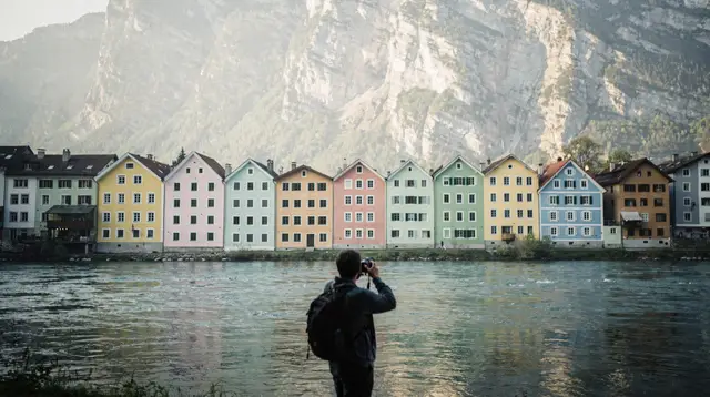
The reason this short walk keeps coming up in every list of free things to do in Innsbruck is the view across the river toward Mariahilf and St. Nikolaus, the two districts on the north bank. A row of narrow townhouses there has been repainted for generations in ochre, red, mustard and pale green, in the fisherman’s and craftsman’s style typical of the valley. Photographed from the old-town side of the river, with the sheer wall of the Nordkette rising directly behind the rooftops, it is one of the most recognisable images of the city — and one that a phone camera captures just as well as any professional shot, because the geography does the work.
That juxtaposition is the whole point of the walk. The city centre is at 574 m; the ridge above Mariahilf climbs to over 2,300 m within a couple of kilometres, with almost nothing in between — no foothills, no gradual buildup, just the valley floor and then the mountain. Few European capital-scale cities put a 2,000 m wall of rock this close to a riverside row of pastel houses, and it reads that way in person as much as in a photograph.
Where to walk
There is no single official route, and that’s part of the appeal — you cannot really do this walk “wrong.” The most common version starts near the Innbrücke, the bridge just north-east of the old town, and follows the embankment on either bank for a stretch in each direction.
On the old-town side (south bank). The path runs along Innrain and the promenade below it, giving a straight-on view across to the coloured houses and the mountain. This is the stretch most people mean when they talk about “the Inn river walk,” and it connects easily to the Golden Roof and imperial quarter walk if you want to loop back into the historic centre afterwards.
On the Mariahilf/St. Nikolaus side (north bank). Walking this side puts you right in front of the coloured facades rather than looking across at them, and it is the quieter of the two banks — fewer tour groups, more locals walking dogs or cycling to work. It is also the side that leads most directly toward the valley station of the Hungerburgbahn, the funicular that climbs toward the Hungerburg plateau and on up the mountain, which makes this bank the natural choice if you plan to ride up afterwards.
Footbridges. Several pedestrian bridges cross the Inn within a few hundred metres of each other, so a simple there-and-back walk on one bank can easily become a loop: out along one side, across a footbridge, back along the other. None of the crossings involve stairs or anything more demanding than a flat bridge deck.
| Stretch | Distance | Time | Character |
|---|---|---|---|
| Innbrücke to Mariahilf houses (one way) | ~0.8 km | 10-15 min | The classic postcard view |
| Full south-bank promenade | ~1.5 km | 20-25 min | Straight sightline to the ridge |
| Loop via two footbridges | ~2.5 km | 40-50 min | Both banks, no repeated ground |
| Extended walk toward Hungerburgbahn | ~3 km | 45-60 min | Ends at the cable car valley station |
None of these figures assume a fast pace — they allow for stopping to look, take a photo, or sit on one of the benches along the embankment.
The Nordkette as backdrop, not as destination
It is worth being precise about what this walk does and doesn’t include. The riverside promenade gives you the view of the Nordkette from below, at 574 m, looking up. It does not take you onto the mountain. If the view from the riverbank makes you want to actually get up there, that’s a separate trip: the Hungerburgbahn funicular, designed by Zaha Hadid and opened in 2007, starts a short walk from the north bank and climbs in stages toward Hafelekar at over 2,200 m. The full mechanics of that ascent, including which of the three lift stages to take and how long each leg runs, are in the Nordkette cable car guide rather than here.
A practical way to think about the two: the Inn river walk is the ground-level version of the view, free and unhurried; the cable car is the paid, high-altitude version of the same relationship between city and mountain. Doing both back to back — river walk first, then the funicular — is a common and sensible sequence, and it’s covered as a pairing in the feature on getting from the city centre to 2,000 metres.
Fitting it around the rest of a visit
Because it needs no ticket, no opening hours and no advance planning, the Inn river walk works best as connective tissue between other things rather than as a destination on its own. A few ways it tends to slot into a day:
- Between the old town and the funicular. Walk the old town in the morning, cross to the riverside for the coloured-houses view, then continue to the Hungerburgbahn valley station for the ride up.
- As an evening cooldown. After a day of museums or a mountain excursion, the flat, level ground and the changing light on the water make it an easy way to close out the day without needing more stamina.
- With a guided walk. Several city walking tours route past this stretch of the river as part of a broader loop through the historic centre, which can be useful if you’d rather have context on the buildings and history than work it out from a map. The Welcome Tour guided city walk covers the old town and riverside together with a local guide, and travellers who prefer a smaller group or a schedule built around them can book a private walking tour of Innsbruck that includes the riverside stretch on request. For a shorter option between other plans, the express walk of Innsbruck with a local is built to fit into a spare hour.
- As part of the Olympic heritage story. The Olympic heritage walk touches the riverside on its way between sites connected to the 1964 and 1976 Winter Games, since several of the routes between venues follow the embankments.
Practical notes
Surface and accessibility. The embankment paths are paved and flat throughout the central stretch, with no stairs on the main route. This makes the walk genuinely suitable for strollers, wheelchairs and anyone who wants scenery without exertion — a contrast to most of the site’s other activity pages, which tend to involve altitude, cable cars or gorges.
Weather. Because the walk stays at valley level, it isn’t affected by the same closures and conditions that govern the high mountains — there’s no lift schedule to check and no season when the path itself is inaccessible. It is, however, exposed to wind funnelling down the valley, and the Föhn, the warm dry wind that periodically sweeps through Tyrol, can make the riverside noticeably blustery even on an otherwise calm day. Winter walking is entirely possible; the paths are cleared, though ice can form in shaded sections near the water.
Photography. The classic shot — coloured houses with the Nordkette behind them — works best from the south bank, roughly opposite the Mariahilf church, in the hour or two before sunset when the light hits the facades directly. Midday sun tends to flatten the colours and can leave the mountain hazy. For a broader look at where else in the city rewards a camera, see the old-town photography spots guide.
What’s nearby if you want to extend the outing. The Maria-Theresien-Straße shopping street and its own walking guide are a short walk from the south bank. On the north side, the path toward the Hungerburgbahn also passes close to the lower reaches of the Hafelekar trail network for anyone continuing on foot rather than by cable car. And if a single day feels too short to cover the river, the old town and a mountain excursion together, the one-day old-town itinerary builds in a version of this exact sequence with realistic timings.
Riverside walk in Innsbruck: your questions answered
How long is the Inn river walk in Innsbruck?
The core stretch, from around the Innbrücke bridge to the Mariahilf and St. Nikolaus riverbank, is under 2 km and takes 30-45 minutes at a relaxed pace with photo stops. Extending it upstream or downstream along the embankment paths can turn it into a 1-2 hour outing.
Where does the Inn riverside walk start and end?
Most people start at the Innbrücke, the bridge just north of the old town, and walk along either bank. There is no fixed start or finish; it works equally well walked out-and-back from the old town side or looped across one of the footbridges.
Why are the houses along the Inn in Innsbruck so colourful?
The pastel red, yellow and green facades on the Mariahilf and St. Nikolaus side of the river are traditional fisherman’s and craftsmen’s houses, repainted over the centuries in the ochre and lime-wash tones typical of the Inn valley. They are one of the most photographed views in the city because they sit directly under the Nordkette.
Is the Inn river walk the same as whitewater rafting in Tyrol?
No. This is a flat pedestrian walk along the embankments inside Innsbruck itself. Whitewater rafting on the Inn and its tributaries happens well upstream, mainly around the Ötztal and the Imster Schlucht, on a different, faster-flowing stretch of water with a completely different set of operators and safety gear.
What’s the best time of day to walk along the Inn for photos?
Late afternoon and early evening give the warmest light on the coloured facades and often the clearest view up to the Nordkette ridge. Early morning is quieter and calmer for reflections in the water, especially outside the summer season when the river carries more glacial silt.
Can I combine the Inn river walk with the Nordkette cable car?
Yes, and it is a natural pairing. The Hungerburgbahn valley station is a short walk from the riverside, so many visitors do the Inn walk first at street level, then ride up for the high-altitude view back down over the same stretch of river.
Is the walk suitable for kids and strollers?
Yes. The embankment paths are flat, paved and stroller-friendly, with benches and playground areas on some stretches. There is no climbing and no entrance fee, which makes it an easy option to slot into a day that also includes paid attractions.
Guided city walks on GetYourGuide
Verified deep-linked GetYourGuide tours. Book through these links and we earn a small commission at no cost to you.
GetYourGuide does not provide a product photo for this activity — the image shows the meeting point, photographed by us.