Cycling the Inn Valley from Innsbruck
How far can you cycle along the Inn river from Innsbruck?
The Inn valley path leaves central Innsbruck at 574 m and runs east past Hall in Tirol and Wattens, or west toward Imst and the Otztal. This site does not publish fixed distances or ride times for the route: check the regional cycling network map for current surfaces and signage before setting a target, especially outside summer.
The River That Runs Through the City
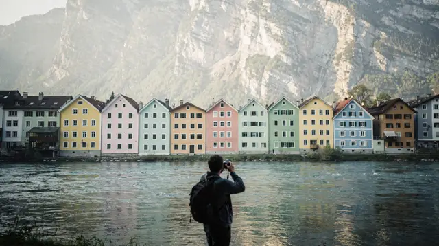
Stand on any of the bridges over the Inn in the old town and the question answers itself before you ask it: the water is right there, moving fast, with the coloured house fronts of the Inn river leaning over it and the Nordkette wall rising behind them. Innsbruck sits at about 574 m in a narrow valley, and the river that gives the city its name keeps going in both directions well past the edge of town. It is a genuinely obvious idea to follow it on a bicycle. The less obvious part is how far to go, and this page is built around answering that honestly rather than promising a number this site has not measured itself.
There is no single, official “Inn Valley Trail” brand the way some Alpine rivers have one continuous signed long-distance route. What exists is a network of riverside paths, valley-floor cycle lanes, and shared-use tracks maintained by the city of Innsbruck and the surrounding municipalities, connecting into each other with varying degrees of separation from road traffic. Locals commute on parts of it. Tourists ride other parts of it for the view. Both directions out of the city are genuinely rideable, and this guide covers what each one offers, what to expect from surfaces and signage, and where to actually find route distances and times, because this page will not invent them.
Starting Point: The River in the Old Town
Wherever your ride begins or ends, it is worth building in time at the river itself, right in front of the old town. The coloured facades along the Inn are one of the postcard views of the city, and the walking path directly beside the water is separate from the road, easy underfoot, and a pleasant place to get your bearings before committing to a longer ride in either direction. If you’d rather explore this stretch on foot first and save the bike for the open valley, the dedicated river walk covers it in more detail, and it pairs naturally with a loop through the old town’s narrow streets before you head out.
From here, the valley opens in two directions: downstream (east, following the Inn toward Germany) and upstream (west, toward the Brenner watershed and the high Alps). Both are covered below.
East: Toward Hall in Tirol and Wattens
Riding east out of Innsbruck along the Inn, the valley stays wide and the gradient stays gentle — this is the flatter and, for most visitors, the more approachable of the two directions. The route tracks the river past the airport side of the valley and brings you within reach of Hall in Tirol, whose medieval old town is, somewhat surprisingly, larger than Innsbruck’s own, and on toward Wattens, home to Swarovski Crystal Worlds. Neither town is covered in depth on this page — each has its own dedicated guide, and Wattens in particular deserves a full visit rather than a quick pass-through on a bike.
What this page will say plainly: the exact riding distance and time to either town depends on which stretch of path you follow, how much of it hugs the river versus cutting through villages, and current maintenance or diversions. Rather than print a number that might already be wrong by the time you read this, the honest move is to pull up the regional cycling network map before you go and read the distance for the specific segment you plan to ride. Public transport back into the city on this side is also relatively easy, which matters if you decide to ride out and take the train or a VVT bus back rather than doing a there-and-back.
West: Toward Imst and the Otztal
Heading upstream from Innsbruck, the valley floor narrows in places and widens in others, and the ride toward Imst and the mouth of the Otztal covers noticeably more ground than the eastern option. This direction suits a longer day, a rental e-bike, or a plan that treats the ride as one leg of a bigger loop rather than a there-and-back on the same day. The valley here is broader and more agricultural in character than the postcard mountain scenery closer to the city, and that is part of the appeal: it is a genuinely different Tyrol than the one on the cable cars.
As with the eastern route, this page does not commit to a fixed distance or ride time for reaching Imst or the Otztal turn-off, because the practical route varies by which paths are currently open and which side of the valley you choose to follow. The regional cycling map is the reliable source for that detail, and it is worth checking not just for total distance but for surface type — some valley-floor stretches are paved, others are gravel, and that changes what kind of bike makes sense.
What the Regional Cycle Map Actually Tells You
Tyrol maintains a signed regional cycling network, and the practical advice here is simple: before you set a distance goal for the day, look up the actual signed route for the segment you intend to ride. The map will show you:
| What to check | Why it matters |
|---|---|
| Segment distance and estimated time | This page does not publish fixed numbers; they vary by chosen path |
| Surface type (paved vs. gravel) | Determines whether a city bike or e-bike is comfortable |
| Separation from road traffic | Some stretches share a road shoulder, others are fully separated |
| Current closures or diversions | Valley-floor paths sometimes close for river maintenance work |
| Connections to train stations | Useful for a one-way ride with a return by rail |
This is a small amount of homework, but it replaces guesswork with the current, correct picture rather than a distance printed on a page that can’t be updated as often as trail conditions change.
If You’d Rather Not Pedal the Whole Way
Not every visitor wants to plan a self-guided valley ride from scratch, and Innsbruck has a reasonably developed e-bike scene to match. Renting an e-bike for the day flattens the difference between the easy eastern stretch and the longer western one, and it takes the edge off riding back into a headwind, which is a common complaint on the valley floor in the afternoon.
If a guided option appeals more than route-planning, a private e-bike tour through Innsbruck’s historic squares is a way to combine the old town and the riverside without worrying about navigation, and it can be a gentler introduction before tackling a longer valley stretch on your own.
For something with more distance and more mountain scenery folded in, a scenic e-bike tour through the hills around the city covers ground a flat valley ride doesn’t, for anyone who wants both in one trip. And for a fuller day with more support built in, a guided panoramic e-bike tour handles logistics, pacing, and route choice for you.
None of these guided options are the valley-floor river ride described above — they lean toward the hills and panoramic terrain around Innsbruck rather than the flat Inn corridor — but they’re worth knowing about if the idea of cycling near Innsbruck appeals more than the specific plan of following the river east or west. For route-planning help geared specifically to self-guided riding, the dedicated e-bike rental and tour guide has more detail on providers and where to pick up a bike.
This Is Not Mountain Biking
It’s worth being direct about what this page covers and what it doesn’t. Riding along the Inn is a valley-floor activity: flat to gently rolling ground, river views, and villages, not singletrack or climbs. If what you actually want is mountain biking with real elevation and technical trail, that’s a different plan entirely — the Bikepark Innsbruck on the Muttereralm and the trail network around the Stubai valley are the places to look, and both are covered in their own dedicated guides rather than here.
If you’re deciding between the two kinds of riding for a single trip, it’s entirely possible to do a relaxed valley ride one day and a proper mountain-bike outing the next; Innsbruck is compact enough that both are realistic from the same base.
Getting Back: Trains, Buses, and Planning a One-Way Ride
One advantage of riding the valley floor rather than a mountain loop is that you’re never far from a station or a bus stop. Regional trains along the Inn valley line, and a number of VVT regional buses, carry bicycles, which opens up the option of riding one direction and taking transport back rather than retracing your route. Rules on bike carriage — supplementary tickets, space limits, time-of-day restrictions during commuter hours — do exist and do change, so it is worth confirming the current policy before you count on it as your return plan. The public transport guide for Innsbruck and the wider Tyrol network is the place to check specifics for IVB and VVT services.
If you’re driving into Tyrol with your own bikes on a rack rather than renting locally, the general rules on the Austrian vignette, the separate Brenner toll, and winter tyre requirements apply regardless of what you’re doing once you arrive, and are worth reading before you cross the border.
When Not to Ride the Valley Route
The single most important caution on this page: do not plan an Inn valley bike ride for the depth of winter without checking conditions first. Innsbruck sits at 574 m, but the valley floor still sees genuine winter weather — snow cover, ice on shaded and riverside sections, and unsalted stretches of path that are entirely reasonable to walk but risky to ride. Nothing on this page should be read as an endorsement of cycling the valley route in full winter conditions.
If you’re visiting between roughly December and March, treat the ride as a fair-weather, clear-road option rather than a fixed plan, and check current conditions locally before setting out. Outside winter — from spring thaw through autumn — the route is a straightforward, low-drama ride in either direction, and it’s one of the easiest ways to see a working, unpolished side of the Inn valley that the cable cars and museums don’t show you.
| Season | Realistic expectation |
|---|---|
| Late spring to early autumn | Reliable riding conditions in both directions; the default season for this ride |
| Early spring / late autumn | Generally fine but check for wet or muddy unpaved sections after rain |
| Winter (roughly Dec–Mar) | Not assumed rideable; ice and snow on valley-floor paths are common — verify locally before riding |
Cycling the Inn Valley: Common Questions
Is there one continuous bike path along the Inn from Innsbruck?
There is a connected network of riverside and valley-floor paths following the Inn in both directions, used by commuters and tourists alike. Sections vary in surface and separation from road traffic, which is why this guide points you to the official regional cycling map rather than naming a single unbroken route.
Which direction is better, east toward Hall in Tirol or west toward the Otztal?
East toward Hall in Tirol and Wattens is flatter, shorter to reach, and closer to public transport for the return. West toward Imst and the Otztal covers more ground through a broader stretch of the Inn valley and suits a longer day or an e-bike.
Can I ride an e-bike instead of a regular bicycle?
Yes. E-bike rental is widely available in Innsbruck, and guided e-bike tours run from the city if you would rather not plan the route yourself. An e-bike makes the return leg against the valley’s prevailing headwind considerably easier.
Can I bring a bike back on the train or bus?
Regional trains and some VVT buses in Tyrol carry bicycles, usually with a supplementary ticket and sometimes with time-of-day restrictions. Confirm the current rules and any seasonal limits at the station or with VVT before relying on this for your return.
Is the Inn valley cycle route open in winter?
No route along the valley floor should be assumed rideable in winter without checking conditions first. Ice, snow cover, and unsalted sections are common from late autumn to early spring, and this guide does not present the ride as a winter activity.
Does the route pass through Hall in Tirol and Wattens?
Riding east from Innsbruck brings you toward both, though this page does not detail either town. Hall in Tirol’s old town and Wattens, home to Swarovski Crystal Worlds, each have their own dedicated guides linked below.
Do I need a mountain bike for this ride?
No. The valley-floor route follows the river and flat ground rather than mountain trails, so a city bike, touring bike, or e-bike is appropriate. Mountain biking around Innsbruck is a separate activity, covered on the Bikepark Innsbruck and Stubai valley guides, and in the cycling and mountain biking category overall.
Where does the colourful row of houses along the Inn fit into a ride?
The Inn river’s coloured house fronts, one of the most photographed views in Innsbruck’s old town, sit right at the start of any ride along the water at about 574 m elevation, making it a natural first or last stop rather than a detour. If you want a longer guided ride through the hills instead of the flat valley, a guided e-bike tour toward the Nordkette starts from the same part of the city and heads up rather than along the water.
Cycling and mountain biking on GetYourGuide
Verified deep-linked GetYourGuide tours. Book through these links and we earn a small commission at no cost to you.
GetYourGuide does not provide a product photo for this activity — the image shows the meeting point, photographed by us.